Having experience in providing hydrogeological survey (hydrogeology services), the company has advantages in determination of hydrogeological parameters, research, forecasting & balance-reserve calculation of groundwater resources, hydrogeological and general physical mapping of materials, modeling and other areas.
Hydrogeological survey (Hydrogeology services):
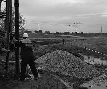
- study of the hydrogeological condition of the project area, experimental works in exploratory boreholes
- analysis of the interaction of aquifers with surface waters, study of the water supply system and its technical condition
- assessment of water resources
- assessment of groundwater pollution
- chemical analysis of water sample
- hydrogeological mapping and hydrogeological modeling, hydraulic property study
- hydrogeological GIS, aerospace and geophysical methods to investigate water sources in potentially probable areas
- determination detection depth of groundwater and thickness estimation of water layers and water horizons, assessment of groundwater
- exploration works on water sources, calculation of hydrogeological parameters
- combination and comparative analysis of geophysical and hydrogeological survey results
Various methodological approaches exist for studying the hydrogeological conditions of any area and investigating water resources. Firstly, researchers analyze cartographic and satellite images to study the physical-geographical conditions of the area. Secondly, they analyze hydrogeological and geological fund materials and maps. Then, if necessary, they conduct geophysical studies and select the optimal locations of regime boreholes. They examine the existing boreholes in the area and perform experimental work. After that, they carry out monitoring of regime wells. At the next stage, they calculate hydrogeological parameters. In addition, they take water samples and chemically analyze them, resulting in water quality studies and pollution assessments. As a result, they draw up a hydrogeological map (actual data map) and carry out hydrogeological modeling. In conclusion, we prepare a report on hydrogeological investigations.
Geomatics services
Environmental services
Hydrography services
Consulting services
IT & System Integration